
Report by Bosky Khanna for The New Indian Express
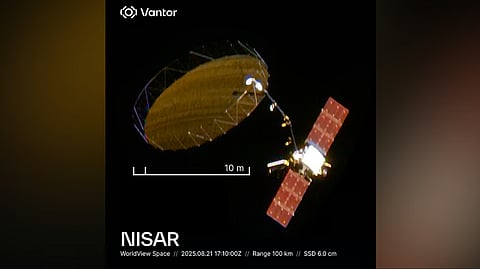
One of the most sought-after satellites -- NASA-ISRO Synthetic Aperture Radar (NISAR) -- was photographed in space by Vantor, formerly known as Maxar Technologies, the company that provides AI- powered spatial intelligence.
It captured an image of NISAR after the world's largest antenna in space, measuring 12 metres in diameter, was fully opened in August 2025.
Vantor took to its social media platform on Thursday to share the image of NISAR taken from Earth's orbit.
It said: "Full bloom on the most powerful radar satellite ever built—seen here with centimetre-level clarity. Vantor collected this image of the NISAR synthetic aperture radar (SAR) satellite after it deployed its giant circular radar antenna reflector in August."
The NISAR has been built jointly by NASA and ISRO. It was launched from the GSLV-F16 from Satish Dhawan Space Centre in Sriharikotta on July 30, 2025.
NISAR had revealed the first images it had taken, in September 2025, of Mount Desert Island and North Dakota Wetlands, Farmlands. The NISAR mission is on track and will start its assigned scientific operations from November.
Vantor said: "The satellite is the largest and is one of a kind ever deployed in space. For high-value assets in space, decision makers don't have days to wait for answers to critical questions. They need fast answers. Our WorldView Space non-Earth imaging capability is built for exactly for this. Here you can see the actual structural state—whether the mesh is properly tensioned, if the deployment geometry matches specifications, and how the spacecraft is oriented relative to its imaging targets. With this image, we also collected spacecraft orientation, velocity data, and deployment confirmation that telemetry alone can't verify. This is the kind of trusted intelligence that delivers total clarity to help you understand what's happening in Earth's orbit."
The satellite will scan the entire globe and provide all weather, day and night data at 12-day intervals, which will be used for a wide range of applications.
The NISAR can detect even small changes in the Earth’s surface such as ground deformation, ice sheet movement and vegetation dynamics. Its other applications include sea ice classification, ship detection, shoreline monitoring, storm characterisation, changes in soil moisture, mapping and monitoring of surface water resources and disaster response.
It has dual-frequency Synthetic Aperture Radars -- L-Band and S-Band and is stationed in the 743 km Sun-synchronous orbit with an inclination of 98.4 degrees.
