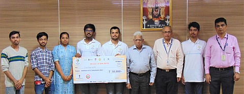

What if you had an app that could tell you in real-time when you're driving if you're approaching a black spot or a high accident spot? Well, now you do and it's called Road Runner. Developed by Information Science students from Nitte Meenakshi Institute of Technolgy (NMIT), it was a product of the Smart India Hackathon organised by the MHRD. This app not only alerts the drivers to dark spots and accident sites, but it also gives you data about previous accidents that have occurred on that particular road. The team, Fazal Rehman, Abhrajyoti Pal, Yash Jaiswal, Amith K K, Deeptha M, Sarang Parikh, Ajay M, and Yashas M, was mentored by their Head of Department Dr Sanjay H A while developing this app.
Though the subjects are picked by the MHRD, this one found a lot of resonance with the team. Sarang Parikh says, "Black spots are nothing but places where the highest number of accidents take place. It might be due to bad roads, overspeeding or a lack of signage. Our team decided to tackle this problem with an app that can give alerts to the riders about dangerous black spots on the road."
With just 36 hours available to develop the app, the team decided to take the data about accidents and black spots from the National Highways Authority of India (NHAI) website. According to these statistics, there are 789 deadly black spots on State/National Highways where over 2,00,000 accidents take place every year, "We fed all this data immediately and interfaced it with Google Maps and ran a message on the algorithm to identify the proximal black spots. Geofencing is a concept we used to create virtual boundaries around the black spots," he explains. When the driver physically enters the geofenced area where the black spot is, he gets an alert on the phone through a visual presentation, voice over or vibration. "As soon as they move away from the Geofenced area, the alerts will stop. The alert could also be about potholes, bad roads, a sharp turn, lack of signage and so on," he adds.
The app also pops a notification when they are driving over the speed limit on a particular road — which is not a feature most navigation apps possess at this point. In order to make their app stand out, they have included real traffic updates and a suggestion feature that provides a safe alternative route where there are no black spots or potholes. In addition to this, the users can view analytics and graphs on how well they drive and how many black spots they've avoided.
Much like Google Maps, Road Runner also has an open source updation system — called Crowd Source, where any user can add black spots that they have encountered. "For instance, if there is a black spot on the way to your office, then one can take pictures of it, mention the location and type of black spot and update it. However, this turns out to be a black spot only if other travellers also flag it. That's why we call it Crowd Source. Similarly, even government bodies can easily mark black spots so that users can be alerted. They can track the progress on improving such black spots and reduce the number of accidents. In order to help the public, they can create a temporary black spot if there is some work in progress on the roads," explains Sarang.
