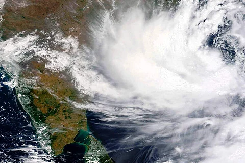
The landfall process of very severe cyclonic storm Yaas has commenced and it would cross North Odisha-West Bengal coasts to the south of Balasore within next three hours with wind speed of 130-140 kmph gusting to 155 kmph.
Cyclone Yaas lay centred at 8.30 a.m. on Wednesday over northwest Bay of Bengal near latitude 21.21 degree north and longitude 87.1 degree east, about 45 km north-northeast of Dhamra, 60 km southwest of Digha and 40 km south-southeast of Balasore, said National Weather Forecasting Centre of the India Meteorological Department (IMD).
As per the IMD's 9.15 a.m. report, the current intensity of the near centre of the cyclone was 130-140 kmph wind speed gusting to 155 kmph.
The cyclone moved north-northwestwards with a speed of about 17 kmph during past six hours.
"Landfall process has commenced. The system would cross North Odisha-West Bengal coasts to the south of Balasore within next three hours as a very severe cyclonic storm with wind speed of 130-140 kmph gusting to 155 kmph," the IMD said.
In Odisha,light to moderate rainfall at most places with heavy to very heavy rains at a few places with extremely heavy falls at isolated places in Jagatsinghpur, Kendrapara, Jajpur, Bhadrak, Balasore, Mayurbhanj, Cuttack, Dhenkanal, Keonjhargarh and heavy falls at isolated places in Puri, Khurda, Angul, Deogarh and Sundergarh is expected.
While in West Bengal, the IMD has predicted light to moderate rainfall at most places with extremely heavy rainfall at isolated places over Medinipur and heavy to very heavy rainfall at isolated places over Jhargram, Bankura, South 24 Parganas and heavy falls at isolated places over Purulia, Nadia, Murshidabad, East Bardhaman, Bowrah, Hooghly, Kolkata, North 24 Parganas, Haldia, Darjeeling and Kalimpong districts on Wednesday.
Light to moderate rainfall at most places with heavy to very heavy rainfall and extremely heavy falls at isolated places is expected in Jharkhand on Wednesday and Thursday.
The wind speed is expected to be about 130-140 kmph gusting to 155 kmph along and off Bhadrak and Balasore districts during landfall of the cyclone and 100-110 kmph gusting to 120 kmph along and off Kendrapara district at the time of landfall is reported.
"Windspeed will decrease gradually after landfall becoming 65-75 kmph gusting to 85 kmph by evening," said the IMD.
Tidal waves of height two-three meters above astronomical tide are likely to inundate low lying areas of Balasore, Bhadrak and about two meters above astronomical tide are likely to inundate low lying areas of Medinipur, South 24 Parganas, Kendrapara and Jagatsinghpur districts around the time of landfall.
Wind speed 80-90 kmph gusting to 100 kmph is prevailing along and off north Odisha coast and 70-80 kmph gusting to 90 kmph is prevailing along and off adjoining West Bengal coast.